Trains, trams, buses, ferries, bikes. You can reach many nature walks and outdoor activities by public transport. There are some real gems a hop skip and jump from Melbourne. Further afield are longer walks and spectacular campgrounds.
Reduce your carbon footprint and enjoy an epic day out with mother nature.
The Dandenong Ranges is a beautiful park right on the edge of Melbourne, famous for its Mountain Ash forests.
It can get busy on weekends – mid-week or early morning are often quieter.
Ramblers Track Loop: 1.5km
Belview Loop: 4.5km
Kokoda Memorial Trail/1000 steps: 3km loop with almost 300m of vertical ascent.
Getting there:
Hop onto the Belgrave Line Train from Flinders Street Station to Upper Ferntree Gully Station. From there, it’s just over a 1km walk to the base of the Kokoda Memorial Trail, where there are three different loop tracks to tackle.
If you’re after a longer day hike, link together tracks to make a larger loop.
French Island is a walkers’ paradise with a variety of tracks. Cycling is also popular – you can bring your own bike on the train or hire one at the general store, 1km away from Tankerton Jetty. Home to a large population of koalas, there is also a diverse range of habitats to explore, from mangrove saltmarshes to woodlands. You can also camp on the island and stay for a longer adventure.
The Old Coast Road Track starts at Tankerton Jetty and is a flat 5km each way.
The West Coast Wetlands Walking Track is also popular for birdlife and orchids. It includes the Pinnacles Lookout for spectacular views of the wetlands, bay and island.
Getting there:
Jump on the Frankston Line from Flinders Street to Frankston Station, then onto the V/Line service to Stony Point. From here, you’ll need to get on a passenger ferry to French Island’s Tankerton Jetty.
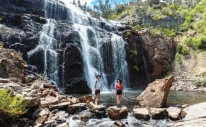
Caption:
MacKenzie Falls Track. Phoot: Parks Victoria
The Grampians-Gariwerd National Park
Halls Gap at the base of the Grampians is accessible by V/Line coach and is very central to Grampians-Gariwerd, with various loop trails accessible from here. Make sure you go to the Halls Gap Visitors Centre to pick up a map of the Southern Grampians.
The Pinnacle Walk and Lookout: 2.1km
MacKenzie Falls Track: 1.9km
Link the two for a longer track
Various campsites are close to the town, including the caravan park and bush campsites. There’s a variety of local accommodation options worth checking out.
Getting there:
Hop on the Ararat V/Line train to Ararat from Southern Cross Station. From here, there are two options: use the Dimboola V/Line coach from Ararat to Stawell and then the Halls Gap V/Line coach to Halls Gap Information Centre; or use the Warrnambool V/Line coach from Ararat to Halls Gap Information Centre.
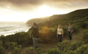
Caption:
Coastal walk, ocean views 📷 Parks Victoria
Great Otway National Park
The Great Otway National Park is a beautiful park to visit and is accessible by public transport.
The Surf Coast Walk: 44km – runs from Torquay to Aireys Inlet. It can be broken up into 12 parts, so you can stop and start wherever you please. You can also do sections in day trips, as most of them start and end in towns with V/Line coach stops.
Ironbark Basin to Anglesea: 9.7km
Currawong Falls Circuit Track: 12km walk – accessible from Distillery Creek Picnic Area in Aireys Inlet. It’s the perfect place to visit after rain, to see the waterfalls in all their glory.
Getting there:
Jump on the V/Line train to Geelong/Waurn Ponds from Southern Cross Station and depart at Geelong. Then onto a V/Line coach towards Apollo Bay. There are several stops along the Great Ocean Road where you can walk to access points along the Surf Coast Walk.
Greater Bendigo National Park/Castlemaine Diggings National Heritage Park/Wombat Forest
The ‘Goldfields Track’ is a 210km track from Creswick/Ballarat to Bendigo for bushwalkers and mountain bike riders. It is relatively flat to hilly terrain.
The trail is broken up into multi-day and shorter sections, in proximity to towns with public transport options at Ballarat/Creswick, Daylesford, Castlemaine and Bendigo. It’s a great way to explore the forests and towns of Central Victoria.
The Ballarat/Creswick to Daylesford section is a multiday walk through farmland and Wombat Forest.
The Daylesford to Castlemaine section is 61km and shows changes in habitat types and the famous Castlemaine Diggings National Heritage Park.
The Castlemaine to Bendigo section shows off Mount Alexander’s granite tors and Box-ironbark forest.
Getting there:
Take the Bendigo/Epsom/Eaglehawk/Echuca V/Line train from Southern Cross Station to Castlemaine or Bendigo. There’s a coach from Woodend Station to Daylesford. If you’re planning to start from Creswick, take a Ballarat/Wendouree line train and there are regional coach services to Creswick. The walks themselves often start/conclude at the train/bus stations.