PARK WATCH Article June 2022 |
Two assessment reports have finally been released for the forests of Mirboo North and the Strathbogie Ranges, writes Executive Director Matt Ruchel.
First announced in November 2019 as part of the Victorian Forestry Plan to transition out of native forest logging by 2030, the Andrews Government’s proposed Immediate Protection Areas to cover about 140,000 hectares of state forest across the Central Highlands, East Gippsland, Mirboo North and the Strathbogie Ranges. While 96,000 hectares of coupes were immediately taken off the logging schedule, well over two years on this protection is still not formalised with legislation (read ‘Commitment issues’ in March 2022 Park Watch).
In 2022, the process to actually formalise the status of these areas continues very slowly.
The Andrews Government finally announced in late 2021 that the Victorian Environmental Assessment Council (VEAC) would undertake assessments of the values of the areas identified for the IPAs, and an Eminent Panel For Community Engagement (EPCE) will carry out a community consultation on the future uses of state forests in eastern Victoria.
VEAC’s assessments have primarily been desktop exercises, with just one report for Mirboo North and one for the Strathbogie Ranges released to date.
While Mirboo North and Strathbogie Ranges have been assessed first, the Central Highlands and East Gippsland are likely to follow later in 2022. Unless protected under the law and their land tenure changed, these areas could again be subject to logging (for instance if a change of state government were to occur).
Mirboo North IPA
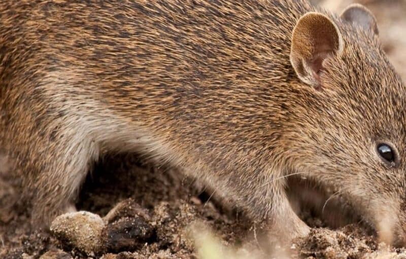
The proposed Mirboo North IPA is on Gunaikurnai Country. It is a small area of state forest (approximately 440 hectares) located north of the Mirboo North township in the Strzelecki Ranges, about 130 kilometres south-east of Melbourne. The Strzelecki Ranges is one of the most heavily cleared bioregions in Victoria, retaining less than one-third of the original extent of native vegetation and one of the lowest proportions in the protected area system at 1.5 per cent. Much of the surrounding landscape is used for agriculture.
The Mirboo North State Forest provides habitat critical for the survival of many animals and plants threatened with extinction; Greater Gliders, Powerful Owls, Burrowing Crayfish, Lace Monitors, Superb Lyrebirds and the Platypus all call it home.
There has been an active campaign by locals, supported by the VNPA, called Preserve our Forests Mirboo North, and the group has produced an extensive report on the values of the area.
The VEAC assessment report for Mirboo North concludes that given the very small size of the proposed IPA, designating it as a ‘regional park’ is considered the most appropriate land use category. It fits well into the landscape, with similar forest in the contiguous block of the Mirboo North Regional Park. It affords protection of the high natural values from sawlog and pulpwood logging, while facilitating continued use of the forest for a broad range of activities. It also provides management continuity and simplifies land boundaries to support public understanding of allowed activities. As a regional park, though, it would not be considered part of the formal protected area system.
However, the VEAC findings are equivocal, noting that “if size and management viability were not a consideration the land use category commensurate with the identified values of the Mirboo North IPA is conservation park. As a conservation park, under-represented EVCs in the Strzelecki Ranges bioregion would be added to the protected area system and the IPA would be managed for the protection of its natural values, while allowing an appropriate level of access and a range of recreational activities valued by the community”.
As part of the VEAC assessment process, the Gunaikurnai Land and Waters Aboriginal Corporation (GLaWAC) assessed the area.
The GLaWAC section of the report points out that while GLaWAC has joint management over ten parks and reserves under the Gunaikurnai and Victorian Government Joint Management Plan, the model for management of the Mirboo North IPA may eventually be influenced by the Victorian Government’s current review of public land and plans to create a new Public Land Act. These potential changes are important and may open the door for different management models as the VEAC assessment progresses.
GLaWAC makes clear that they are not in favour of the Mirboo North IPA moving under the National Parks Act 1975, and notes in the report that “since the Victorian government is in the process of reviewing public land, any lasting decision on the Mirboo North IPA should not pre-empt those opportunities. For that purpose, GLaWAC would seek for the Mirboo North IPA to continue to be managed under existing State legislation”.
Strathbogie Ranges IPA
The proposed Strathbogie Ranges IPA is on Taungurung Country and comprises the entire Strathbogie State Forest. It is located about 120 kilometres north-east of Melbourne, east of the Hume Highway at Euroa. The IPA would cover approximately 24,000 hectares of public land, currently classified as state forest, of which 5,000 hectares are a Special Protection Zone.
The area is a hotspot for Greater Gliders and a range of other threatened species, including Eastern Horseshoe Bat, Brush-tailed Phascogale, Powerful Owl, Murray Spiny Crayfish, Grey Rice-flower, Tall Leafy Greenhood, and Hairy Hop-bush.
There has been a long-running and active campaign by the Save Our Strathbogie Forest (SOSF) to protect the area from logging and other threats, which VNPA has supported.
According to the VEAC assessment report for the Strathbogie Rages, a ‘conservation park’ is considered the most appropriate public land use category commensurate with the values of the central and northern parts of the proposed Strathbogie Ranges IPA. For the remaining south-western part of the IPA, ‘forest park’ is considered the most appropriate land use category.
Areas of the IPA in a conservation park would be subject to additional conservation measures and would be managed for the protection of their natural and cultural values, while allowing access for a range of recreational activities. Important threatened species habitat, including many large, hollow-bearing trees, would receive a higher level of protection. All under-represented Ecological Vegetation Classes (EVC), including those in the Central Victorian Uplands bioregion in the northern part of the IPA and in the east near Lake Nillahcootie, would be added to the formal protected area system.
According to VEAC, a forest park in the south-western part of the IPA would facilitate continued use of the forest for a broad range of activities and could accommodate firewood collection, hunting, mining and recreational prospecting.
A rapid biocultural assessment of the Strathbogie Landscape was undertaken by Taungurung Land and Waters Council (TLaWC) and is published in the VEAC assessment report.
According to the report, Taungurung favour continued management of the Strathbogie Ranges IPA under the three existing Crown Land Acts until the new Public Lands Act is passed and the rights it provides Traditional Owners are better understood. Interim planning, management and governance arrangements that support Taungurung rights and interests and that are enabled in the Victorian Traditional Owner Cultural Landscapes Strategy are proposed. Creating a forest park under the Forest Act 1958 and appointment of TLaWC as a Committee of Management will improve Taungurung rights to govern areas within the Strathbogie Cultural Landscape while navigating planned legislative change.
The VEAC assessments are one of the inputs into the process, and each Traditional Owner group is also represented on Eminent Panel For Community Engagement.
New models for public land management
The VEAC assessment for proposed Immediate Protection Areas raises the aspirations of Traditional Owners.
The aspirations of Traditional Owners for control and use of public land must be respected and the questions around which model best suits will need to be an ongoing conversation.
The Committee of Management model, pointed to in the VEAC IPA assessment reports, is still widely used for a lot of public land across Victoria, especially for coastal campgrounds and urban parks. However, it is not without challenges.
One of the motivators for the foundation of the VNPA in the 1950s was that the places called national parks, like Wilson Promontory National Park, were managed by Committees of Management, who were generally cash strapped and government outliers. This created a tension where extractive uses such as logging and grazing were required to fund management and infrastructure. This perverse tension was one of the bases of our aim to encourage a centralised and consolidated conservation management agency, ideally properly funded by the state.
Under the current legislative models, the challenge to ensure access to consistent resources for management will be faced by any Committee of Management, whether Traditional Owners or otherwise.
Victoria’s proposed public land reforms are a salient feature of the VEAC assessment reports for the IPAs. Following the Statewide Assessment of Public Land by VEAC in 2017, the Andrews Government is proposing to replace three existing Crown Land Acts (the Crown Land (Reserves) Act 1978, Forests Act 1958 and Land Act 1958) with a new Public Land Act. The new Public Land Act will operate alongside the National Parks Act 1975, which will continue to protect significant parts of Victoria’s diverse natural environment.
Current legislation relating to public land does not recognise the significance of Traditional Owners’ connection with land and waters as fundamental to identity and culture, and it does not support self-determination. An important reason cited by the state government for wanting to review and update the legislation is to recognise, enable and support self-determination for Traditional Owners and other Aboriginal Victorians.
A range of current public land categories or tenures will be merged. While the Andrews Government has committed that “…proposed reforms will not change any current land uses…” there will be some changes to names and possibly purposes of different types of reserves. For example, the title of ‘state park’, long confused with ‘state forest’, will be removed and these areas renamed national parks or other types of reserves in the National Park Act. New ‘conservation park’ and ‘nature park’ categories will be introduced into the National Park Act and cover some of the existing flora and fauna reserves and nature conservation reserves. The new Public Land Act will consolidate 16 other reserve types, including state forest, bushland reserves, coastal reserves, and alpine resorts.
A consultation paper for the review was released in 2021 and VNPA provided detailed input. We understand legislation is being drafted and could be completed this year, or early in the next term of government (depending, of course, on who wins). However, what is not clear from the consultation paper is the different models proposed to encourage Traditional Owner management or control, as to date the only formal joint management arrangements have been under or via the National Parks Act.
VNPA will continue to closely monitor these important developments, continue working closely with local groups, and seek to get final recommendations that support aspirations of Traditional Owners and strong protection and management for Victoria’s special natural places.
Did you like reading this article? You can read the latest full edition of Park Watch magazine online.
Want to be kept up to date about this and other nature issues in Victoria? Subscribe to our email updates.
You can also receive our print magazine Park Watch four times a year by becoming a member. Find out more.